現在に作成中の戸倉上山田温泉周辺のハイキング・サイクリングマップの為に、最後に一つの山の登り口を確認したかった。マップは割と簡単に作れるけど、そのマップを手に入れて、実際使ってみる人達はコースが分からなければ意味がないという事で…
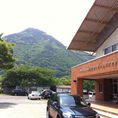
上山田と坂城町の間にある岩井堂山。三角のお結びの形していて、「お結び山」とも呼ばれている。
地元の小学校は遠足で毎年に登る。(我が二男のKen君は先週に遠足で登ったばかり。)ですから、地元で皆が知っている。
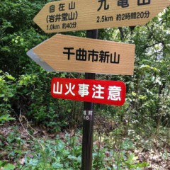
ただ、登る口の看板は一つもない。駐車場もないし、途中まで行く林道は4WDじゃないと無理だし、一般の人でどうやって案内するか困っていました。
市役所の方やいろんな地元の人達と相談したら、上山田トレセンで車を止めて、林道を登れば、山の肩(尾根?)に隣の坂城町が作った看板がちゃんと出ていて、安心で登れるでしょうと、このコースを決定しました。
どうして上山田川に看板がないだろう?町おこしはやはり、看板から始まること、よく分かりました。
We are almost finished making a new Hiking / Cycling Map for Togura Kamiyamada Onsen. There was one last hiking course that I wanted to verify before putting the map to print. There's no use in making a map with courses people can't actually find.
Iwaido-san is the triangular-shaped mountain situated in between Kamiyamada and neighboring Sakaki Town. Our 8-year old son Kenny climbed it along with his classmates as all Kamiyamada Elementary School 3rd graders do for their annual outdoor excursion. So it's a well-loved mountain with the locals. There just aren't any signs for visitors to find it.
I've come to realize that civic improvement starts with good signage!


