東信の一番高い山: 2568mの浅間山。小諸や軽井沢を通り度にいつも浅間山を見上げる。頂上から堪えずに煙が出ていて、恐るべしな火山。
先日は長男が珍しく学校が休みで、今年は浅間山を登る約束したのでこのタイミングを活かして、登山してきました。
浅間山の登山は主に2ルートがある:
1400mの天狗温泉から一の鳥居、二ノ鳥居、火山館径
2000mの高峰高原案内状から黒班山径
高峰高原の登山口は標高が高いけどアップダウンが激しいから決して楽じゃないそうです。どちらも片道三時間半ぐらいかかります。
私達は天狗温泉浅間山荘からの方を選んだ。鳥居通りの方が何となく「正しい」様に思ったし、途中の火山館の神田館長に会いたかったし、最後は天狗温泉に入りたかったから。
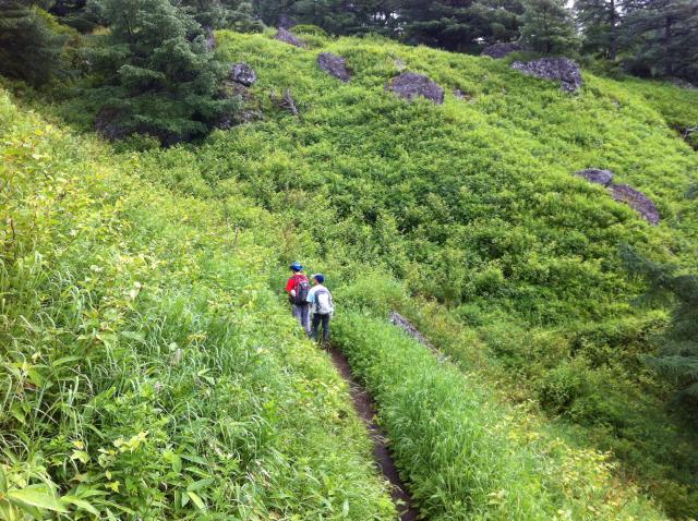
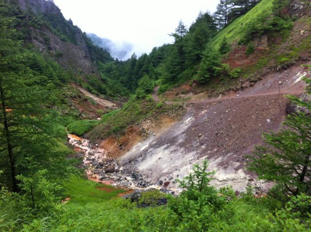
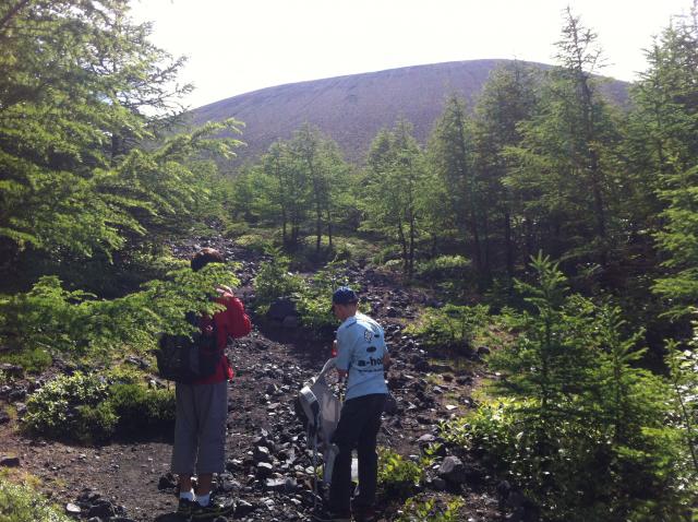
浅間山荘で車を駐車して(有料:500円)、森の中の道から登ります。途中の山野菜や鳥居の写真を撮りながら登って、途中で笹の草原に入り、硫黄の香りに赤い石、そして雄大の牙山が見えて、段々と火山の世界に入りました。
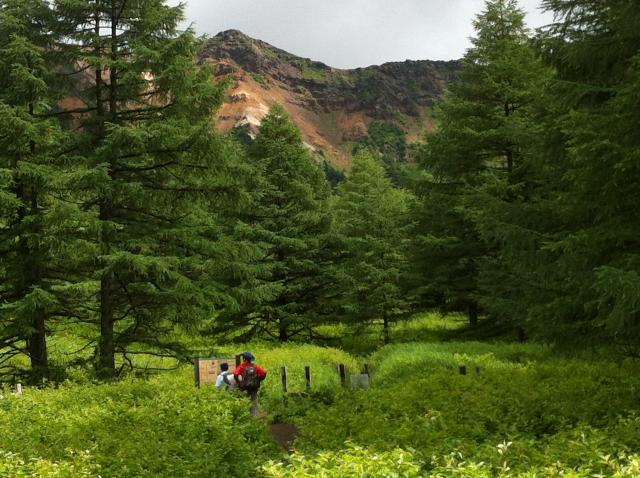
その直後、火山館に辿り着いた。休憩しながら、館長の神田さんに浅間山の色々なうんちくを教えて頂いて、やる気満々で再度出発しました。まずは紫のアヤメが咲いている湯の平。自然なアヤメは初めて見て、感動しました。
湯の平から離れて、植物から離れて、高峰高原ビジターセンター・黒班山・Jバンド経由の道が一緒になって、火山の石の道となって本格的な斜面を登る様になる。遠くの群馬県嬬恋村を見下ろしながらとにもかくも上に登る。
浅間山は本当は3つの火山です。3つが重なっている。一番古いのは長径2㎞火口で、今に残っているのは2404m黒班と2254~2366mのJバンドです。その上に2つ目の火山が出来、その火口は2524mの前掛山です。1783年の噴火でその中に三つ目の火口が出来、2568mの浅間山(釜山)、日本百名山となる。
現在の火山警戒レベルは「1」で、釜山の登山は禁止というか、自己責任というか、まあ、禁止です。と言いながら、ちゃんとした道がある。釜山から火山の煙がほとんどいつも出ているので毒ガスは目で見えないので危険です。従って、火口まで登って中にのぞかないで前掛山から見た方がお勧め。
浅間山登山。
三つの火山、
三つの地形(森、草原、火山石)
忘れられないし、今回は通らなかった場所と道を通りたいし、また登りたい♪
登る前に小諸市のHPで火山の噴火状況を確認してね。
At 2568m, Mt. Asama is the largest mountain in eastern Nagano. The active volcano towers over Komoro and Karuizawa, frequently sending up plumes of volcanic ash and smoke. The Nagano Shinkansen is named after Mt. Asama, and riders of the bullet train get a front seat view of the awe-inspiring mountain.
But what does the world look like from the top of Mt. Asama? And can you see into the volcanic crater? I had always been curious, so on a recent day when our oldest son had a day off from middle school, we decided to make an ascent of the volcano.
There are 2 main climbing routes for Mt. Asama. Both involve driving or taking a bus up Cherry Park Road from Central Komoro towards Takamine Kogen. Partway up is a branch to the right signed 浅間山登山口 -- Trailhead to Climb Mt. Asama. (If coming by bus, get off here and walk.) That road turns into a dirt track and ends at 1400m Tengu Onsen Asama Sansou hotel and campground. Park your car if you drove (500 yen) and from there, start hiking.
The 2nd route starts at 2000m Takamine Kogen which would seem easier due to the higher elevation, but ends up taking about as much time due to a lot of up-down business and Mt. Kurofu along the way.
We chose the Tengu Onsen start because that route is the original pilgrimage path with Ichi no Torii and Ni no Torii gates. The Kazankan ranger station-like shelter is on the way and we wanted to say 'hi' to Kanda-san, the director. Of course, we also were looking forward to a bath in Tengu Onsen's rusty-red waters at the end.
After leaving civilization (i.e. Tengu Onsen) behind, the trail basically follows a creek through a forest up to the Yu no Daira meadow, a relatively flat bit of respite from the ascent. Along the way to Yu no Daira, there were colorful wildflowers beside the path, spots in the creek where the water was a brilliant shade of orangeish red, a side path to Fudotaki waterfall, the before-mentioned torii arches, and a clearing named Kamoshika-daira, a crossroads of sorts for 4 heards of kamoshika, the ubiquitous stubby Japanese serow.
As the thick forest gives way to a equally thick carpet of sasa bamboo grass, the path turns a corner and you come face-to-face with the imposing Kibayama ("Fang Mountain"). Here the stream bed puts on a show of mineral colors while a strong scent of sulfur fills the air -- sure signs you are heading into volcano territory.
Another bend in the path and you arrive at Kazankan. If you speak Nihongo (Japanese), have Kanda-san explain the geological wonders of Mt. Asama. It is actually three volcanoes-in-one, with the three consecutively built on top of each other -- the only one like it in the world.
After bidding Kanda-san farewell, it's another brief incline before reaching Yu no Daira, a wildflower-filled flat meadow. Then the ascent begins in earnest. Once you leave the scraggly pines, you enter the volcanic rock zone and your first views of the barren summit. Actually what you can see is Maekake Mountain, the remains of the 2nd of 3 volcanoes. The path ends at the 2524-meter top of Maekake, giving you an unimpeded view of the 3rd volcano, 2568m Kamayama, formed by a volcanic eruption in 1783.
Currently Mt. Asama's volcanic activity is at level 1, which means access is technically limited to Maekake. But there is a path up to Kamayama's crater edge for those brave souls who, taking full responsibility by themselves, wish to peer into an active volcano crater. The path up is well travelled, so apparently there are a lot of brave souls out there.
Climbing Mt. Asama --
Three volcanoes in one,
Three very varied terrains (coniferous forest, alpine meadow and barren volcano rock),
it all makes for an unforgettable experience.
My son Andy and I are looking forward to climbing Mt. Asama again to try some of the other paths and explore areas we didn't get to on our first ascent.
Before you go, check the Komoro City website for current volcanic activity info.
小諸市浅間山登山情報 Komoro City Mt. Asama Climbing Info
Mt. Asama Tengu Onsen Trailhead
1st torii gate
2nd torii gate

Kibayama (Fang Mountain)
Hiking through the sasa bamboo grass carpet

Serow Meadow
volcanic creek

Yunodaira
J-Band trail
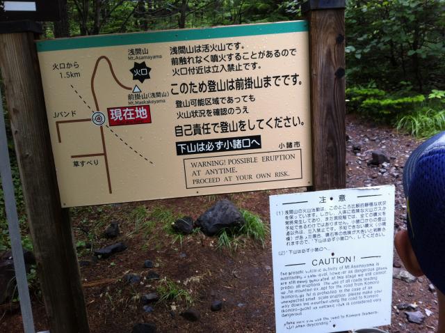
Warning Sign
Start the Ascent

Looking back at the inner side of the J-Band

At the crater's edge
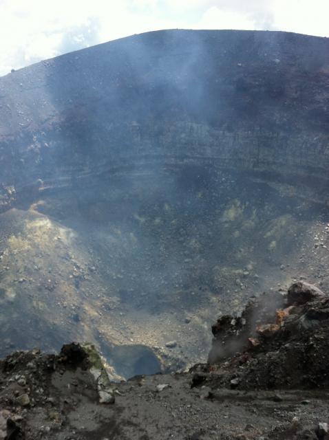
Deep into the crater