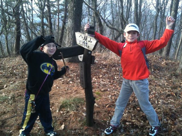
We made it to the Top!
戸倉上山田温泉の西側に大林、八頭、冠着という山が立っています。上山田小学校の校歌にも出ます。この間の日曜日の天気が12月らしくない暖かったので、子供達と一緒にその真ん中の1204mの八頭山を登りました。
上山田と築北村をつなげる坂北トンネルの前に車を駐車し、Andy君(10歳)とKen君(7歳)が自分の足で、美咲ちゃん(3歳)がパパのバックパックに乗って、4人で登って行きました。山頂の下のポンポンの平(名前は可愛い!)でおにぎりを食べました。その時に、長野山友会のメンバーと行き会って、山登りの情報を交換しました。亀清のお風呂にも誘ってあげてみましたが、そういうところじゃなかったみたい。(もったいない。山登りと温泉が最高なコンビだと私が思っていますが…)そして、最後の急な坂をチャレンジ!山頂に着いたら大喜び!
冬の山登りの良い所は気に葉っぱがないから、景色は良く見える。山頂から戸倉上山田温泉街や坂城町、遠くの湯の丸高原が綺麗に見えました。
じゃ、今度はポンポンの平(またその可愛い名前)への坂下り。僕らが命をかけて(?)、その急な坂を下りていると、負んぶされている美咲ちゃんがいびきをかいている。贅沢だな。
八頭山のハイキングメモ
登山口: 県道55号@坂上トンネル前
登山口標高: 830m
八頭山山頂標高: 1204m
距離: 1300m
標高差: 370m
時間: ご参考に、私達は1時間20分がかかりました。(ポンポン平での休憩を含めて)
On Kamiyamada's western flank, Obayashi, Hatto and Kamuriki mountains are lined up next to each other. They have such a noticeable presence that they are featured in Kamiyamada Elementary School's official school song.
This past Sunday was unusually warm for December, so the kids and I went for a hike to the top of the middle of those three mountains, 1204-meter Hatto-san. It was a thigh-busting hike to the top (especially for me as I carried our daughter Misaki in a backpack), but we made it and were rewarded for a great view of the Chikuma River valley below.
During a post-climb soak in our onsen back at the inn, our son Kenny exclaimed that next he wanted to go climb Obayashi Mountain. Looks like a mountain climbing fan has been born!